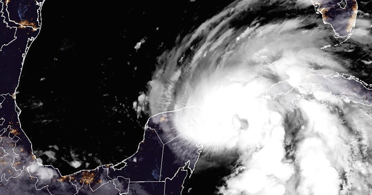
Helene forecast to make landfall tomorrow night
Helene is forecast to make landfall along the Big Bend of Florida tomorrow night between 6 and 10 p.m. as a major hurricane.
Helene’s outer rain bands will bring on-and-off tropical downpours to South Florida and the Keys by this afternoon. Tropical storm-force winds will begin for Key West to Miami by later this evening.
Tomorrow, wind gusts 60 mph and higher, tornadoes, and storm surge flooding are expected along the west coast of Florida, including the Tampa area. Conditions will then quickly go downhill for the Florida Panhandle and Big Bend area by tomorrow afternoon.
Tomorrow night, Helene is forecast to make landfall and hurricane-force wind gusts are likely for the I-10 corridor across Florida and into southern Georgia. Major wind damage and power outages are likely along with significant urban and river flooding.
On Friday, Helene is forecast to remain strong as it pushes inland. It could maintain hurricane strength into southern Georgia. Major wind and rain impacts from north Georgia into the western Carolinas are forecast. Life-threatening flash flooding is expected for parts of Georgia, North Carolina and South Carolina.
NHC: Helene nears hurricane strength
Tropical Storm Helene is nearing hurricane strength with maximum sustained winds of 70 mph. A Category 1 hurricane has winds of 74 to 95 mph under the Saffir-Simpson Hurricane Wind Scale.
It’s forecast to become a hurricane later today and rapidly strengthen into a major hurricane on Thursday, the National Hurricane Center said in its 8 a.m. advisory.
Swirling about 60 miles east-northeast of Cozumel, Mexico, Helene is moving northwest at almost 9 mph. Helene is forecast to pass near the northeastern coast of the Yucatan Peninsula this morning, and move across the eastern Gulf of Mexico later today and Thursday, and reach the Big Bend coast of Florida late Thursday.
A tropical storm warning, already in effect for all of the Florida Keys, the Florida west coast from Flamingo to Anclote River, including the Tampa Bay, has been extended to include the Florida east coast from Flamingo northward to Altamaha Sound, Georgia.
Evacuations ordered across Florida’s coastline
- Pinellas County: Mandatory evacuation orders were issued for health care and long-term care facilities in Zone A, St. Petersburg Mayor Ken Welch said Tuesday.
- Levy County — Mandatory evacuation orders for coastal communities, low-lying areas, mobile and manufactured homes.
- Taylor County — Mandatory evacuation orders for all of the county, with shelters in Alachua County.
- Charlotte County — Evacuations orders for barrier islands, low-lying and flood-prone areas, and manufactured homes.
- Citrus County — Mandatory Evacuation orders for nursing facilities and assisted living facilities in Zone A.
- Hernando County — Mandatory evacuations starting Wednesday at 8 a.m. for all areas west of US 19.
View the full list of evacuation orders here.
Tropical Storm Helene expected to grow to Category 3 hurricane
Emergency evacuations are underway in Florida as Tropical Storm Helene is expected to grow into a massive and destructive Category 3 hurricane. “TODAY’s” Al Roker tracks the projected path of the storm.
Biden approves Florida’s emergency declaration
President Joe Biden last night declared an emergency in Florida and authorized the Federal Emergency Management Agency (FEMA) to coordinate disaster relief efforts as Helene approaches.
Florida Gov. Ron DeSantis had requested the disaster declaration on Monday and he declared a state of emergency in 61 counties in the state.
The president’s authorization will see federal assistance and reimbursement for “mass care including evacuation and shelter support.”
University of South Florida cancels all classes ahead of Helene’s arrival
The University of South Florida ia taking no chances as the state braces for the impact of Tropical Storm Helene tomorrow, likely as a hurricane.
The college has canceled all classes through Monday and closed access to its campuses until at least Friday.
“The University of South Florida continues to monitor Tropical Storm Helene. The safety of our students, faculty and staff is our highest priority as we track the storm and the possible impacts to the Tampa Bay region,” the college said in a statement this morning.
Tropical storm and storm surge warnings extended across Florida
Florida is set to be hit hard by Tropical Storm Helene, forecasters said today, ahead of its likely arrival as a hurricane late tomorrow.
The National Hurricane Center said in a 5 a.m. ET update that its list of warnings and watches had grown overnight, with a hurricane warning already in place for Florida’s west coast, from Mexico Beach to the Anclote River.
A hurricane watch is in place for a stretch of coastline from the river down to Englewood.
“Preparations to protect life and property should be rushed to completion,” the NHC said.
A storm surge warning, meaning there is danger of life-threatening inundation in the next 36 hours, is in place for almost the entirety of Florida’s west coast from Indian Pass, south-east of Panama City, down to Flamingo in the Everglades National Park on the tip of the peninsular. This warning includes Tampa Bay and Charlotte Harbor.
Across the upper portion of the west coast, the storm surge could reach between 10 and 15 feet.
And a tropical storm warning is in place for Florida’s west coast, much of the east coast, and all the Florida Keys.
Cancun’s beaches empty as Helene heads toward Mexico
A few visitors at the tourist hotspot Cancun were still on the beach on Tuesday, despite warnings that Helene was approaching Mexico’s Caribbean coast.
Florida braces for Helene to hit, potentially as a Category 3 hurricane
NBC News meteorologist Angie Lassman on Early Today forecasts the direction, size and strength of Helene as it heads toward Florida.


Leave a Reply